A Southern Utah Honeymoon
September 26 - October 5, 2003
| |

|
|
Bob approaching Arizona HS
|
We headed to Vegas for a little desert trip a couple weeks ago. After
renting the car and checking into our hotel, and then the usual ritual of
going to a sports shop to buy stove fuel that we can't carry on the plane,
we drove out to Hoover Dam.
Across Hoover Dam into Arizona, and just 4 miles further, is a trailhead on
the right. The sign reads "Arizona HS", but I'd previously known
the spring as "Ringbolt". Anyway, this would be my third visit here. Close
to town, short hike, a first-rate spring set in a slot canyon,
petroglyphs along the way, and not even all that popular. What's not to
like? Well, it was a bit warm out was one problem, well into the 90s, but
that would change soon when the sun went down. We cooked dinner above the
spring, and had a great soak before hiking back out by headlamp.
| |

|
|
Wall Street, Bryce NP
|
| |

|
|
Cathy on the Navajo Loop, Bryce NP
|
Next: To Utah. We drove through Zion without stopping (can't do everything
in one trip) and proceeded to Bryce. What with the kind of long drive, we
only had time for a short hike, and did the very scenic Navajo Loop, which
includes the famous Wall Street, where pine trees reach up high out of
narrow slots to find sunlight. We watched the daylight fade from Sunset
Point. And then the next morning watched daylight arrive from Sunrise Point;
we felt like such tourists! And, after a parking lot breakfast, we hiked the
Fairyland Trail, a longer trek than the previous day's loop hike, with more
of that magical Bryce scenery all the way.
| |

|
|
Sunrise Point, Bryce NP
|
| |

|
|
Cathy near Sunrise Point, Bryce NP
|
After Bryce, we drove eastward on Utah's well-recommended Route 12, which
cuts across the Escalante - Grand Staircase area. There's a popular hike out
here, not far from the Escalante River, to a surprisingly lush waterfall,
Lower Calf Creek Falls. After 3 miles of hiking in the hot desert air, we
reach a waterfall and an ice-cold pool at its base. I swam as close to the
splashdown as I could, but the flow pushed me away; I arose from the pool
shivering. This hike also features a cross-canyon view of three near-life-
size petroglyph figures; we looked across at them and, imagining them
watching over us on our vacation, called them the "Super Friends".
| |

|
|
Lower Calf Creek Falls
|
| |

|
|
"Superfriends" petroglyph, Lower Calf Creek Canyon
|
After the hike, we made our first mistake... eating in Escalante. We figured
that Boulder (that's Boulder, Utah, the last town in the USA to have a road
put in to it, not Boulder, Colorado), where we were going to stay that
night, wouldn't have much going on for food, so we went in to your basic
inbred eatery and had mediocre "burritos" and a "salad" of colorless
lettuce. Then we arrive in Boulder to find that the Hells Backbone Grill,
just written up in the September issue of Oprah Magazine, was open until
10PM.
Oh well, we had a wonderful (and quite inexpensive) breakfast there the next
morning. There's a museum in town, Anasazi State Park, where we mostly
chatted with the ranger types about trails to hike. Not that we were about
to do anything spontaneous, mind you, the main targets of this trip were
planned well in advance, but it's always worth getting the scoop on what to
do next time. This guy had never even been to Lower Calf Creek, "too
crowded".
Next up was a pretty drive across Capitol Reef NP's narrow midsection via
the Burr Trail. Here we have a nice redrock canyon that the road rolls into
the southern end of and follows for a while, then resuming to continue
eastward to the top of the Waterpocket Fold, where the road takes a dramatic
drop down a steep east face. Fine drama without even getting out of the car!
We'd get out soon enough though, after a stretch of southbound dirt to the
Hall Canyon Overlook, near the southern end of Capitol Reef NP. We put on
backpacks and started down the very rugged trail into the Grand Gulch. 800
vertical feet lower, we were in a broad canyon with a variety of cliff
features to either side. We had some lunch and proceeded southward for
several hours.
Getting to the Hall Narrows is a bit of a trek, not just on account of the
mileage, I guess 10 miles or so each way not including the Narrows itself,
or even because a lot of it is slow muscle-wearing sand walking. There's the
weighty matter of it being rather hot, and with no water anywhere. Now,
supposedly, there was going to be water in the Narrows, so we started with
only a little over a gallon for each of us, heavy enough certainly, but not
enough for a long-mileage two days, not at all comfortably anyway. So, just
in case, we were rationing our supply. "You're sure there's water there,
Bob?" "Yes, I'm almost positive there should be water."
We finally found a stretch of creekbed where there was a line of water along
one edge, and stopped to down about a liter of warm water out of each of our
packs. Our spirits lifted considerably, we proceeded another mile to the
entrance of the Hall Narrows.
| |

|
|
The Hall Narrows
|
The deal here is that we'd been following a dry wash downstream southbound
for hours, and suddenly, the canyon starts ramping upward again; where does
the water go, like, when there's water? Well, of course, it goes sideways
right into one of the cliffs! The drainage turns right, the and rock walls
start to rise. Then, a few bends in the (now quite wet) creek later, the
rock walls are hundreds of feet high. Big, grand overhangs become routine.
We camped at a left-turn, where walls throughout the curve are continuously
radically overhung; you look up away from the walls and see an opening
parabola of sky.
The acoustics were rather interesting. We'd clap, hoot, drop rocks, and so
on, to test the echo responses to different sound frequencies. Really
doubled the fun of campsite belches too. And we heard bats all evening as if
they were right on top of us.
| |

|
|
Cathy in the Hall Narrows
|
The next day, we left our campsite in place, and continued down the narrows.
Mostly wading through shin-deep water, with fun bits of quicksand that
looked like sandy shoreline, but turned out to be shin-deep just like the
creek. Not much else to say about this place but wait'll I post the photos.
| |

|
|
Cathy in Hall Narrows
|
Towards the end, we found a spot where, yup, we really were going to have to
get fully wet. I tip-toed in until my fanny-pack was about 1/3 submerged.
Mindful of the fact that I had camera gear in the upper 1/3, I backed off
and considered other options. There was the right-side rock slope: I could
give Cathy a boost up and she could climb around to see if that actually
went. "No way", said Cathy. OK, so I'll give it a try.
| |

|
|
Reflection pool, Hall Narrows
|
| |

|
|
Cathy in the Hall Narrows
|
I frictioned up the first bit. Now 8 feet above the water, I had another 6
feet until I was home free. I made a delicate move, reaching a sloping foot-
hold. Hmmm, not so good. I hung out there for about a minute, feeling my
muscles tire. I looked down, to see that downclimbing wouldn't work too
well; I'd probably lose stability before reaching the lower foothold. Then
my left foot started to slip; I grunted and went for it, pushing off the
right foot with all the momentum that smear hold was good for, and making
the move.
The rock slope made it past the swim, just barely. I got myself to a place
where Cathy could hook her pack on my foot, and she swam to the other end,
where I lowered our gear to her before downclimbing. And soon after we were
out of the Narrows. A long hike out got us back to the car right around
sunset.
| |

|
|
Cathy swims a section of the Hall Narrows
|
Our next trek involved a bit of 4WD. Fortunately, we'd rented a shiny,
nearly new Jeep Grand Cherokee. In fact, the main reason why we'd flown in
to Vegas instead of Salt Lake was because 4WDs rent for about $200 less
there. I guess they figure in SLC a rental 4WD is really going to get used,
but in Las Vegas it's just another premium vehicle for people who want to
cruise around Vegas like a big shot. Whatever, the price was right and there
we were rolling towards Canyonlands NP. Soon, after more than 50 miles of
dirt roads, we were at the viewpoint, and there they were, the fabled
switchbacks of the Flint Trail.
| |

|
|
Jeep road to The Maze
|
The Flint Trail. OK, you Ed Abbey fans know exactly where I'm going with
this... into The Maze. The next 16 miles, from top of the Flint Trail to the
Maze Overlook, took a full 2 hours. When I could upshift to regular 1st
gear, we felt like we were really moving! But the Cherokee is a competent
vehicle, and it rumbled through the worst that it threw at us. Partly thanks
to skilled driving, honed from years of piloting Subarus over harsher
terrain than they're really meant for, I did fine, only scraping bottom a
dozen times in the whole round-trip.
| |

|
|
Island In The Sky, from The Maze, Canyonlands NP
|
Finally, we reached road's end, at the Maze Overlook. We'd be out for four
days, so we started with 2 gallons of water for each of us. The ranger said
we'd find small water sources in a few particular spots, but given the
general isolation down there, I wanted some extra insurance compared to the
lesser water quantities brought into Hall Canyon.
The floor of the Maze is about 700' below the rim, and in between are a
stack of almost uninterupted cliff bands. There are about a half-dozen entry
points that are semi-reasonable, the one that drops from Maze Overlook
having one class 3 section and numerous other bits of class 2. I had a 9mm
climbing rope, which we used for lowering packs in a few spots, and also to
belay Cathy in one section (on the return in the easier up direction, we
didn't use the rope at all).
| |

|
|
Cathy near Maze Overlook
|
So what's it like in The Maze? Well, getting past all the Ed Abbey stuff
(Hayduke's Last Stand was definitely on my mind as we started down from the
top), it's worth mentioning that these canyons are neither "grand" nor slot
canyons; things are roughly around the logarithmic midpoint of those two
extremes in canyon scale. But, while the place isn't exactly spectacular,
being in such a weirdly consistent cliff-bound universe (and it does feel
like its own world down there), where everywhere you go you has the same
cliff-bands with side-canyons that have more of the same cliff-bands,
definitely grows on you.
| |
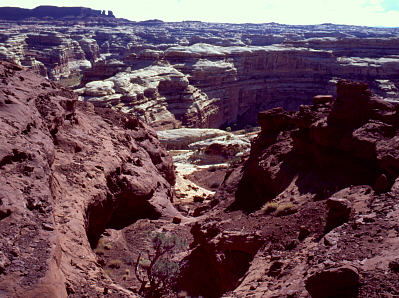
|
|
Looking down into The Maze from near Maze Overlook
|
Our weather forecast was for each day was for 20%, 30%, then 20% chances of
rain, with "partly cloudy" for the final day. Well, we really beat the odds,
because it started raining the first night, pouring by 4AM, and keeping us
tent-bound much of Day 2 (Cathy'd left Desert Solitaire in the car, so we
were left sharing my copy of "Running the Amazon", a really fun book, BTW).
Rain stopped in the afternoon so that we could wander over to the Harvest
Scene, an impressive set of petroglyphs about 3 miles from our camp.
For Day 3, it started merely cloudy, so we headed out early for a grand loop
of the place, heading all the way up Pictograph Canyon, scrambling out at
Lizard Rock, hiking the jeep road past The Wall (where we got heavy rain
again, briefly), to re-enter the Maze at the top of South Fork canyon, and
then down-canyon back to camp, a very full day.
| |

|
|
The Land of Standing Rocks; The Plug is on the right
|
| |

|
|
Bob in the Land of Standing Rocks
|
For the last day, I was concerned about more rain making things muddy on our
steep roads, so we jammed out early. It didn't start to rain again until an
hour before the Flint Trail switchbacks, so we had some muddy sections (it
really messed up the vehicle; back in Vegas they were going to charge me a
$35 "cleaning fee" until I said no, I'll take it to a car wash and clean off
all the mud myself), but it wasn't muddy enough to strand us.
| |

|
|
Cathy climbs out of The Maze
|
On the way back, we spent a late-afternoon at Goblin Valley State Park, had
dinner at the very fine Diablo Cafe, and the next day got a good soaking at
Mystic Hot Springs, a funky, friendly outpost in Monroe, Utah, run by a
fellow out of the Grateful Dead scene; that's yet another Utah spot we'll
definitely be returning to.
| |

|
|
Goblin Valley
|
| |

|
|
Cathy in Mystic Hot Springs
|
-Bob Akka, 10/6/03
Go to BobSkiing.com Home Page